
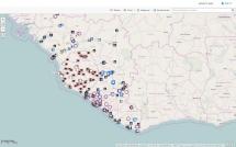
NGA Ebola Map
This is a geospatial map of Liberia, Guinea, and Sierra Leone noting treatment facilities, airfields, public transportation, religious instiuttions, embassies, and refugee camps and can be used by managers and policy makers to help in making programmatic decisions and plans.
Source: National Geospatial-Intelligence Agency
Date of Publication: March 25, 2019
SIMILIAR RESOURCES
Tools
Examples
- Community Communication MNCH e-Manual: Participatory Health Promotion Sessions
- How Should Community Health Workers in Fragile Contexts be Supported: Qualitative Evidence from Sierra Leone, Liberia and Democratic Republic of Congo
- Nutrition Social and Behavior Change Strategy Library
- Using Media and Communication to Respond to Public Health Emergencies: Lessons Learned from Ebola
- Ajustement à bases factuelles des mesures de santé publique et des mesures sociales / Evidence-based Adjustment of Public Health and Social Measures
- Crisis and Outbreak Communication Pandemic Flu and Other Disasters
- Prevent, Detect, Respond: How Community Health Workers can Help in the Fight against COVID-19
- The Importance of Social and Behavioral Change Response in the Zika Outbreak: Lessons Learned from Ebola
- Guide to Strategic Communication Online
- Generic Algorithm to Aid Action Planning at District and Regional Levels